Based in Helsinki, Finland, the start-up Terramonitor represents the world’s most up-to-date and comprehensive map of the globe, comprised of more than 100 million images. By harnessing artificial intelligence and satellite data, the company supports their customers to make better decisions.
We spoke with co-founder Lauri Häme about how the company was created and where they see it evolving in the future.
Spaceoneers: Tell me a bit about your company.
Lauri Häme: We are focused on the downstream space business. We are trying to get most out of the data that comes from satellites by using artificial intelligence (AI) and machine learning. We are developing fully automated processing chains, so we can convert the raw data form satellites into a form that can be integrated for our customers’ geographic information systems (GIS). We are focused on Earth Observation; optical and radar satellite data are our two main data sources.
We now have a team of six people. We started two years ago with two founders. This year we have been growing and next year hopefully up to twenty people.
Spaceoneers: How did the company get started?
Lauri Häme: I have a background in mathematics and while I was working as a researcher, I did some consulting projects with different companies related to satellites data. We noticed that up to date satellite data is quite hard to acquire at the moment. Companies want to use it, but they don’t have the means to get access to it or it may take a lot of work to do so. They have to get raw data from the satellites and process it before they can use it. This problem is where were conceived our solution.
We’ve also noticed that there is lots of activity in hardware development but very little for downstream, so that is why we selected this particular business line.
Spaceoneers: What makes Terramonitor different or special?
Lauri Häme: We make integration very simple. Satellite data integration into any GIS for customers that are that is accessible and up to date. We also use a wide range of open and commercial satellite data sources and combine them using artificial intelligence to produce the best up-to-date maps to our customers.
Last summer we had our first seed investment round. We also recently had our first subscription customers, so we are already receiving some revenue. Our product launch also recently took place, so we hope this brings more customers along as well.
Spaceoneers: Are you using data from the Copernicus Earth Observation programme?
Lauri Häme: Yes. The Sentinel-2 satellite is our main source of data for this service.
Spaceoneers: Are you connected with the digital scene here in Finland?
Lauri Häme: Yes, there is much going on from the software side, but there are no companies that are focussing on satellite data. In general, software development is in a good situation in Finland (such as software and application developers).
Finland has a great infrastructure for start-ups. We have businesses supporting small companies and we also have the ESA BIC program which is also good for these new companies. We have been working with Finnish government for forestry projects and satellite data so that’s also a big focus here for Finland. This industry is one of the country’s main economies.
Spaceoneers: What are some of the applications of the data that you are processing?
Lauri Häme: Finland is known for forest monitoring, so we can track the forest life cycle from seedlings to fully grown forests that can detect changes. When there are flooding or even illegal logging or cutting activity, we can notice this automatically to provide this information to the proper authorities or enforcements. This service has already been operational this year. All of the major forest companies are now part of our customer base that rely on our service for forest management operations (such as scheduling based on satellite data).
Spaceoneers: Tell us more about this product launch.
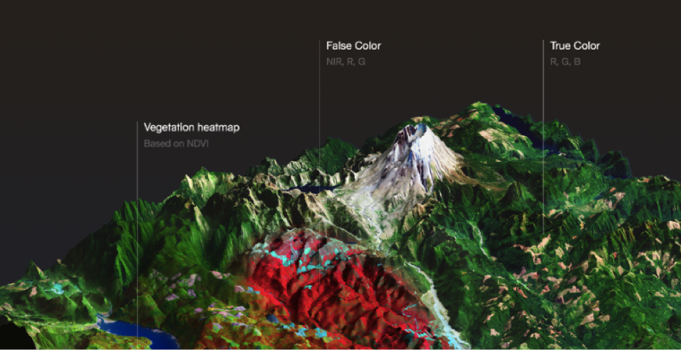
Lauri Häme: The idea started from this demand for forest monitoring, so we are expanding our efforts more globally. We will have an up to date satellite map that covers entire land areas around the world. We are hoping to get customers form different industries. The product is designed to easily integrate to any GIS and it has different layers (including true colour, false colour, history layers to detect changes between time stamps and a vegetation layer) that can detect changes in vegetation. This is useful for both forestry and agriculture.
Spaceoneers: So, is it primarily land monitoring that you focus your services on?
Lauri Häme: We are initially focused on land areas but we will expand our service to the oceans in the near future by adding new satellite data sources.
We are always trying to keep up with technology. We want to take advantage of all the new space data as it becomes available – this is our mission. We want to be the smartest space data refiner.