The world currently is facing some unprecedented challenges. The impact of the coronavirus pandemic is being felt throughout society as it significantly disrupts our everyday lives. The effect is clear on the global economy with many of us forced to work from home and to adapt to remote working practices. Many sectors have had to furlough their staff, as they are unable to do their jobs without coming into contact with people, whereas others have adapted their services to be fully online. It is a very different world. Much of this we can see from satellites in orbit around the Earth. But how can space technologies support the efforts to combat COVID-19?
PROVIDING Free, full and open data to combat COVID-19
The European Union’s flagship Earth Observation Programme – Copernicus – is offering over 16TB of free, full and open data through its 30+ owned satellites together with in situ (non-space) data. These vast amounts of data are being used to provide critical information to help service providers, public authorities and other international organisations to combat COVID-19.
Combined with analytics tools and artificial intelligence algorithms these data are helping the scientific community and public authorities to better understand the consequences of the crisis, to mitigate its potential impacts and anticipate new models for the recovery period.
To help exploit the wealth of Copernicus resources in ways that could be useful in the fight against the Coronavirus epidemic, the five Copernicus DIAS are offering new users the opportunity to sign up for a free trial period. See more at: https://www.copernicus.eu/en/eu-space-actions#eus-dias

#WEkEO #DIAS cloud computing services, along with its extensive portfolio of #EarthObservation #BigData, will be offered free of charge for all projects fighting the #COVID19 pandemic. Contact us for a free account! pic.twitter.com/a4gmng40jd
— WEkEO_dias (@WEkEO_dias) April 8, 2020
supporting authorities and citizens against COVID-19 through gnss applications
Global navigation satellite systems (GNSS) support authorities and citizens by providing accurate location-based information. They may help emergency responders to provide vital resources for the most vulnerable or help citizens navigate the outdoors safely and know when to avoid ‘peak’ times in supermarkets.
ESA BIC UK incubatee Lanterne have developed a free social distancing app called “Crowdless” providing real-time info on the crowdedness of supermarkets. Lanterne uses open source information, precision GPS technology and high-resolution satellite images to help people navigate outdoors safely against COVID-19.

The European GNSS Agency (GSA) have listed the location-GNSS-Galileo based applications that, in its view, may be useful in response to the diffusion of COVID-19 (link here). The applications cover a wide range of uses, from the support to public authorities in understanding the dynamics of the outbreak to the support of citizens in their everyday life, for example by checking and possibly limiting queues at supermarket.
Monitoring Mobility and Transport
Many countries have had to enforce social distancing measures to reduce the spread of the virus. The effects of this can be seen through tools such as Citymapper, which recently unveiled the Citymapper Mobility Index to document the drop in trips planned on its app. Its underlying data is pulled from a variety of sources, including open data. Some data is user-generated or collected by local employed personnel.

The effect of social distancing is clear on satellite images showing many public gathering spaces are now empty. As reported in Business Insider, Space technology company Maxar has provided satellite imagery of different public areas across the globe before and after social distancing measures related to the COVID-19 coronavirus.
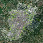
Copernicus has also been monitoring the impact on traffic at borders between EU Member States. Travel bans across Europe have caused serious disruptions in traffic and many trucks carrying medicines and other goods remain blocked at the borders. It has contributed to informed decision-making by national authorities.
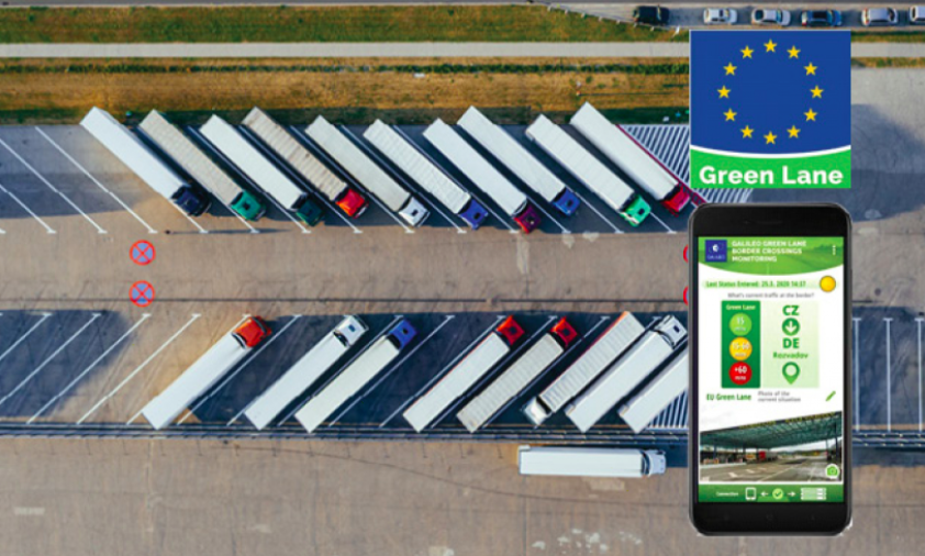
The European GNSS Agency (GSA) is working together with the European Commission (EC) on an app to facilitate the movement of goods and freight within the EU in support of the COVID-19 pandemic response. The “Galileo Green Lane” app will ease the flow of freight through borders and enable the efficient transit of critical goods. Read more at the GSA.
ASSESSING THE EFFECTs OF IMPROVED air quality
The restriction to mobility have seen a dramatic decrease in air pollution in many countries. Most notably some of the larger capitals around the world including Delhi (pictured) have seen a massive reduction in smog. According to CNN, “major cities that suffer from the world’s worst air pollution have seen reductions of deadly particulate matter by up to 60% from the previous year, during a three-week lockdowns period.”

Meanwhile, in Europe, the Copernicus Atmosphere Monitoring Service (CAMS), operated by the European Centre for Medium-Range Weather Forecasts (ECMWF) has expanded its support for those assessing the effects of these lockdown measures on air quality.
The #CopernicusAtmosphere Monitoring Service has expanded our support for those assessing the effects of #COVID19 lockdown measures on #AirQuality with a new tool, powered by @INERIS_fr.
Explore it yourself under Emissions Scenario➡️https://t.co/i6z7R6MDyK pic.twitter.com/GISq0ezwLA
— Copernicus ECMWF (@CopernicusECMWF) April 17, 2020
Swiss company, IQAir, specialising in technology solutions that help protect people from airborne pollutants released a report: “coinciding with the 50th anniversary of Earth Day, this report investigates the impact COVID-19 lockdowns have had on global particulate pollution levels”. The report analyses levels of PM2.5 (fine particles) reported by ground-level monitoring stations in 10 major global cities. Download here in PDF.
FILLING THE GAP IN Weather forecasting
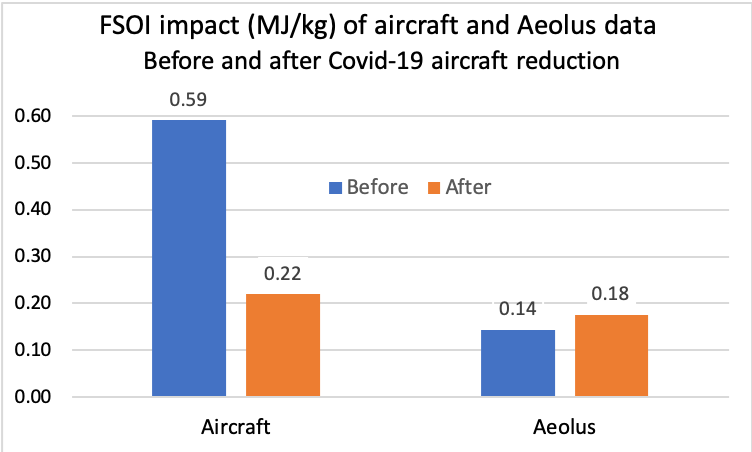
The drop in commercial flights has led to fewer measurements for weather forecasts, but fortunately, ESA’s Aeolus satellite mission is helping to fill the gap. As reported by ESA, “Under normal circumstances, commercial aircraft equipped with sensors supply measurements of temperature, wind speed and wind direction in the atmosphere below 13 km. Without these measurements, the weather forecasts we take for granted everyday would be much less accurate.”
“ESA’s Aeolus mission was specially built to demonstrate how new spaceborne technology could profile Earth’s winds to understand how wind, pressure, temperature and humidity are interlinked – contributing to climate research and to forecasting the weather.”
Supporting the Expansion of Healthcare Facilities
The Copernicus Emergency Management Service (EMS) provides regular information bulletins to help assess the temporary health facilities and public gathering places during the COVID-19 emergency. A recent Politico article highlighted how Copernicus EMS shows worldwide efforts by governments to promptly construct healthcare facilities that treat COVID-19 patients.

New #Informationbulletin on EMS assessment of temporary health facilities and public gathering places during the #COVID19 emergency in Italy. Full story and products here: https://t.co/Joy63j5g3A pic.twitter.com/AyIThh4W6z
— Copernicus EMS (@CopernicusEMS) April 16, 2020
HELPING TO MINIMISE DISRUPTION TO Agriculture
EU satellite data provides modernisation and simplification of the Common Agricultural Policy (CAP). Within the context of the lockdown restrictions and travel bans, it has become very complex for the Paying Agencies across the EU to perform the relevant on site checks for farmer subsidy declarations.
The Farm Sustainability Platform helps mitigate disruptions caused by the Coronavirus. FaST will help lay the foundations of a comprehensive digital ecosystem for sustainable farm and land management in Europe. It provides solutions for sustainable and competitive agriculture based on space data (Copernicus and Galileo) and other data public and private datasets.
